Bridging Art, Digital Production and Immersive Technology
Spanning four decades, Gavin D. Farrell's career from the mid-1980s to the 2020s reflects continuous evolution at the intersection of art and technology. What began as a teenage passion for large scale mural art led to formal training in the 1990s and eventually to trailblazing work in digital media. Farrell has consistently been an early adopter of new technologies in service of creative ends: from animation and web design in the early 2000s, to VR advertising experiments, to today's immersive cinematic experiences.
AI Integration Consultancy (2022–Present)
Building on three decades of adapting to emerging technologies, Gavin has embraced the generative AI revolution as both creative tool and production methodology. Since August 2024, he has worked as an AI Integration Specialist, developing custom workflows that harness the rapidly evolving landscape of AI image and video generation tools. His expertise spans leading platforms including Midjourney, Flux 2, Kling, Veo 3.1, Seedream, and Nano Banana, each offering distinct capabilities for different creative applications.
Rather than treating AI tools in isolation, Gavin builds integrated pipelines using aggregator platforms such as Weavy.ai and ComfyUI, which allow complex multi-step workflows combining multiple AI models, traditional compositing, and post-production refinement. This systems-level approach mirrors his earlier work developing custom VR camera rigs and stitching pipelines: identifying the limitations of off-the-shelf solutions and engineering bespoke workflows that serve specific creative outcomes.
Recent client work includes creating static and video assets for luxury brands and gaming companies, where AI-generated imagery must meet exacting brand standards while accelerating production timelines..
Early Artistic Career and Mural Work (1980s–1990s)
Gavin D. Farrell's journey began with a foundation in fine arts and a teenage passion for large-scale public mural art in the 1980s, inspired by the monumental public artworks transforming American cities, which evolved into formal training and a distinctive artistic voice.
He earned his Bachelor of Fine Arts from the Rhode Island School of Design (RISD) in 1996, developing a hyper-realistic illustration style and deepening his commitment to large-scale public art. During this period, Gavin established himself as a muralist, apprenticing under renowned Los Angeles mural painter Kent Twitchell, one of the defining figures of the American mural renaissance. Gavin served as one of Twitchell's assistant painters on mural projects, gaining hands-on experience with the physical and logistical demands of creating art at architectural scale. This apprenticeship honed his eye for detail, his understanding of how images function in public space, and his ability to work within complex technical constraints.
By the late 1990s, Gavin was combining traditional art skills with emerging digital techniques. As a RISD student, he explored animation and storytelling alongside illustration, laying the groundwork for his eventual transition into digital media and technology.
Transition to Digital Media (2000s)
In the 2000s, Gavin pivoted from purely fine art into the technology realm of animation, creating Flash Webisodes for the animation company STICKYFLICKS.

He attended the Gnomon School of Visual Effects in Hollywood (2004–2006) to merge his artistic expertise with cutting-edge digital tools, learning the technical foundations of visual effects, 3D modeling, and motion graphics that would later inform his immersive media work.
This training led to roles at Warner Bros. Television and Ignited Agency, where Gavin designed interactive microsites and digital campaigns for clients including Sony Vaio, Fox Networks, and the U.S. Army. His work at Ignited increased site traffic by 250% and conversions by 25%, demonstrating an early ability to translate creative vision into measurable engagement.
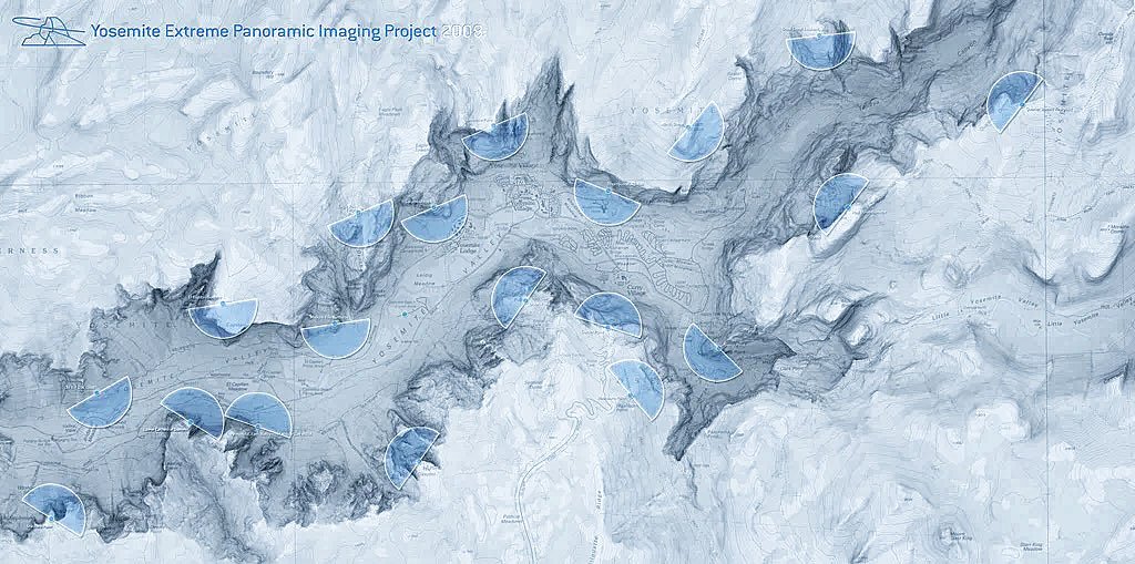
Yosemite Extreme Panoramic Imaging Project (2007-2008)
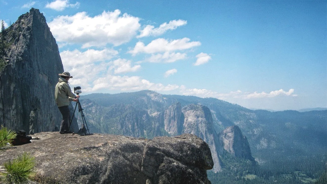
Gavin worked with xRez Studio on the Yosemite Extreme Panoramic Imaging Project. This groundbreaking collaboration with the National Park Service aimed to create a 3.8-gigapixel photographic map of Yosemite Valley's rock walls for geological research and rockfall analysis.
Gavin joined one of 20 teams equipped with prototype GigaPan robotic pan-tilt heads and Canon cameras, hiking to precise GPS coordinates to simultaneously capture over 10,000 overlapping images across 16 miles of the valley. The resulting imagery, projected onto LiDAR terrain models and stitched into 90,000-pixel-wide composites, proved immediately valuable when October 2008 rockfalls injured visitors, directly influencing the closure and relocation of 300 structures near Camp Curry. Gavin later credited Yosemite as the moment his "passion for panoramic photography solidified," launching the trajectory that would lead to even greater projects.
Yahoo! Ad Creative Technology (2007–2017)
Gavin joined Yahoo! in 2007 as Senior Designer, beginning a decade-long tenure that transformed him into an innovation leader at the company's Hillsboro, Oregon campus. Rising to head Yahoo's digital ad innovation team, he pioneered VR and 360° advertising campaigns, developed rich media formats including full-page takeovers and AR experiences, and designed Tumblr's first sponsored post templates following the acquisition. His campaigns—including the Diet Dr Pepper "Hunt for the Unbelievable" series featured in the New York Times—consistently boosted engagement by 20% or more. [Please click here to learn more about Gavin's 10-year career at Yahoo!]

Much of Gavin's impact came through rapid prototyping: when Yahoo's sales team needed to pitch a never-before-seen concept to a major client, he built the demo. Many of these prototypes became actual ad products. This decade of experimentation, bridging art direction, software development, and business strategy within a major tech company, gave Gavin both the technical vocabulary and entrepreneurial confidence to launch Panogs in 2014, even while still employed at Yahoo.
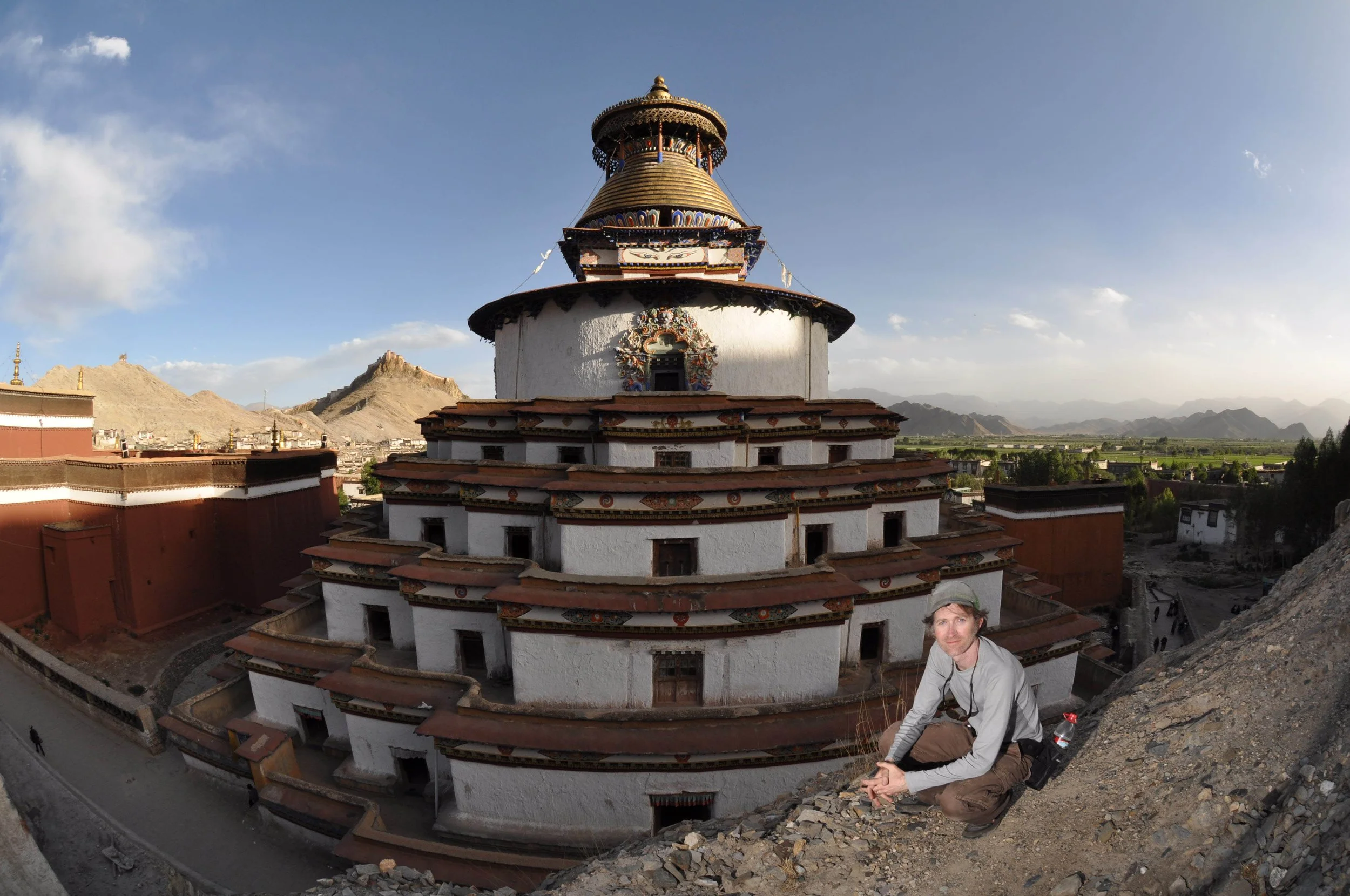
Cultural Heritage Imaging: Murals of Tibet (2010–2018)
Work Presented to His Holiness the Dalai Lama
Merging art and technology in service of cultural preservation, Gavin applied his panoramic photography expertise to one of the most ambitious heritage documentation projects ever undertaken. At the behest of the Dalai Lama, he directed multi-year photographic expeditions to capture Tibet's ancient temple murals in ultra-high-resolution.
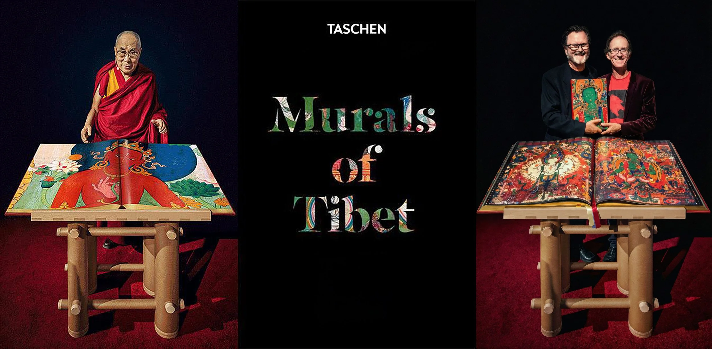
Over eight years, Gavin developed custom panoramic rigs capable of capturing imagery in challenging conditions: ancient monasteries with limited lighting, fragile surfaces that prohibited flash photography, and remote locations accessible only seasonally. Using gigapixel photography, he documented dozens of sacred wall paintings with extraordinary detail invisible to the naked eye.
This effort culminated in Murals of Tibet (TASCHEN, 2018), a massive collector's edition art book featuring those panoramas, one of TASCHEN's most acclaimed publications. The work was presented to the Dalai Lama himself in 2018. Gavin's project ensures these fragile artworks, facing environmental and political threats to their physical survival, are preserved digitally for future generations. It represents not merely documentation but a form of cultural preservation at the highest technical and artistic level.
Co-Founding Panogs and Immersive Media Innovations (2014–Present)
In 2014, Gavin Farrell co-founded Panogs LLC, an interactive media agency devoted to immersive media and experiential design. As Panogs' Director of Innovation, he combined fine art sensibilities with virtual/augmented reality and interactive technology, delivering groundbreaking projects for major landmarks and brands. Panogs quickly became known for pushing the boundaries of immersive storytelling.
The studio's approach distinguishes itself through technical ambition married to narrative purpose. Rather than treating immersive technology as spectacle, Panogs develops custom capture systems and production workflows that serve storytelling first. This philosophy has attracted clients ranging from Sports Illustrated and Time Magazine to Intel and Microsoft, each seeking immersive experiences that transcend gimmickry to create genuine audience connection.
Featured Projects
Time Magazine: One World Trade Center Panorama (2014)
Featured on TIME Magazine Cover | Showcased by Facebook for Global 360° Photo Feature Debut (2016)
In 2014, Gavin was one of the creators of an unprecedented 360° gigapixel panorama from atop One World Trade Center in New York City, then America's tallest building. The final image captured the entire NYC skyline from 1,500 feet up, a vertiginous perspective on Manhattan and the rebuilt World Trade Center site that had never before been possible.
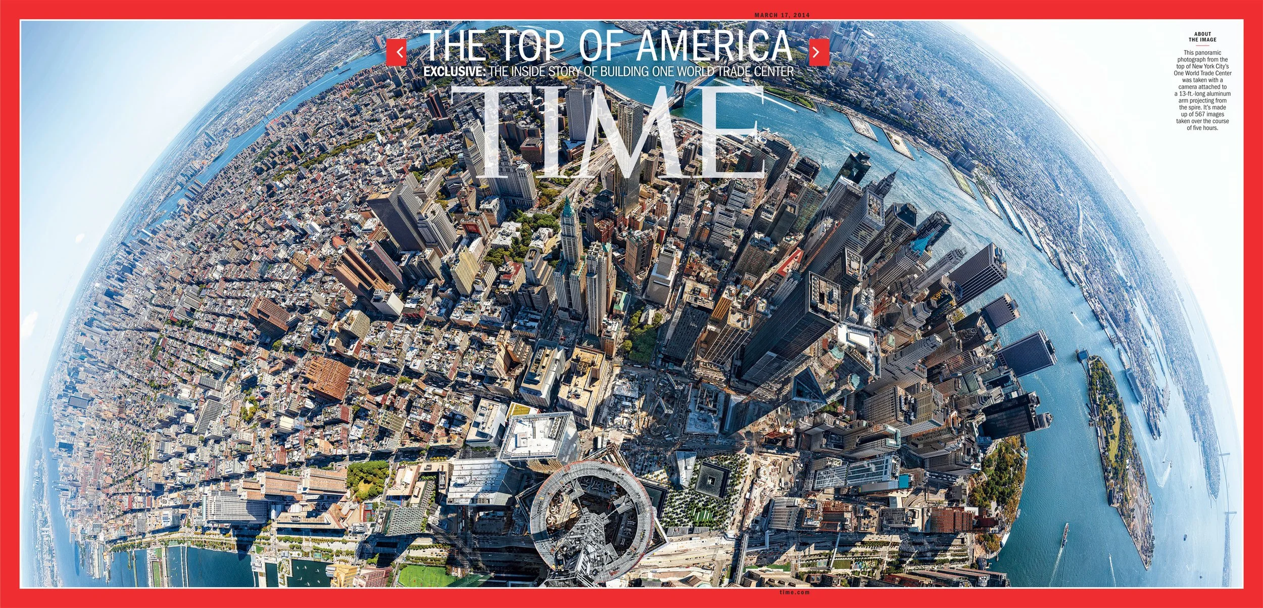
The panorama was so iconic it became a three-page fold-out cover of Time Magazine, introducing millions of readers to the possibilities of immersive photography. Two years later, Facebook's Mark Zuckerberg personally selected this image to demonstrate 360° photos on the platform, introducing the format to Facebook's global user base. The project demonstrated how a single well-executed image could define an emerging medium's possibilities for mainstream audiences.
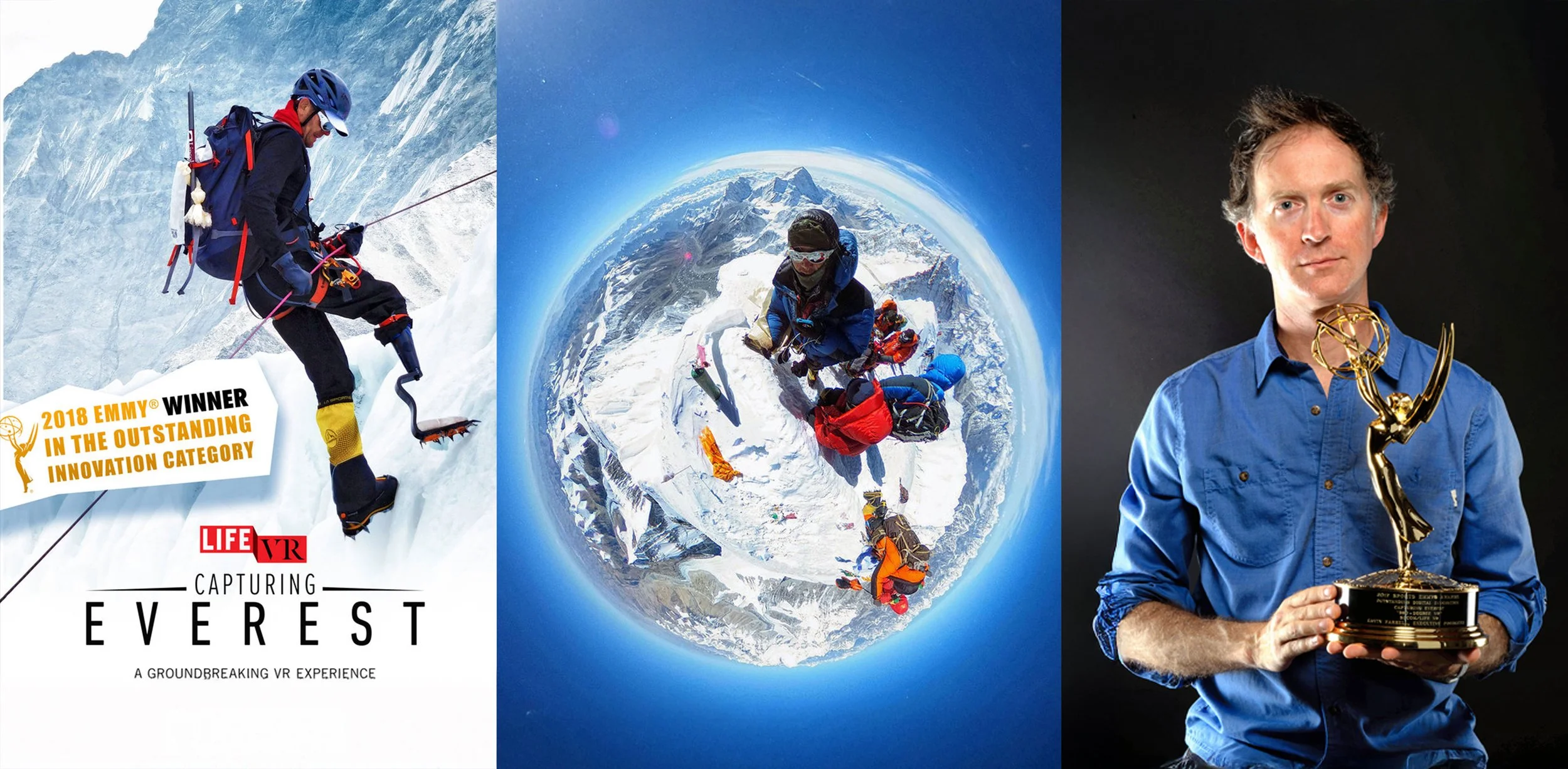
Capturing Everest VR (2017–2018)
Gavin's most acclaimed achievement came with "Capturing Everest," a groundbreaking four-part virtual reality documentary produced in collaboration with Sports Illustrated and Time Inc.'s LIFE VR. The immersive experience chronicled a full climb of Mt. Everest in 360°, transporting audiences into conditions that kill dozens of climbers each year.
Here's the revised text:
The project demanded technical innovation at every stage. Standard VR equipment fails at 29,000 feet: batteries drain in minutes, lenses fog, and equipment operators struggle with hypoxia. Gavin's team developed cold-weather housing, optimized power management systems, and trained climbers to operate specialized 360° camera rigs and drones while ascending the world's highest peak. Custom equipment had to be designed specifically for extreme high-altitude conditions where commercial gear simply cannot function.
The result transported audiences into the death zone itself: the grinding exhaustion of the Khumbu Icefall, the eerie silence of high camps, and the overwhelming emotion of summiting. Capturing Everest won a Sports Emmy Award for Outstanding Digital Innovation in May 2018, cementing Panogs' reputation as a top-tier VR content studio and proving that immersive journalism could captivate mainstream audiences in ways traditional documentary cannot.
Immersive Installations at Landmarks
Under Gavin's leadership, Panogs became a preferred vendor for observation decks, museums, and landmark destinations seeking to transform how visitors engage with iconic locations.
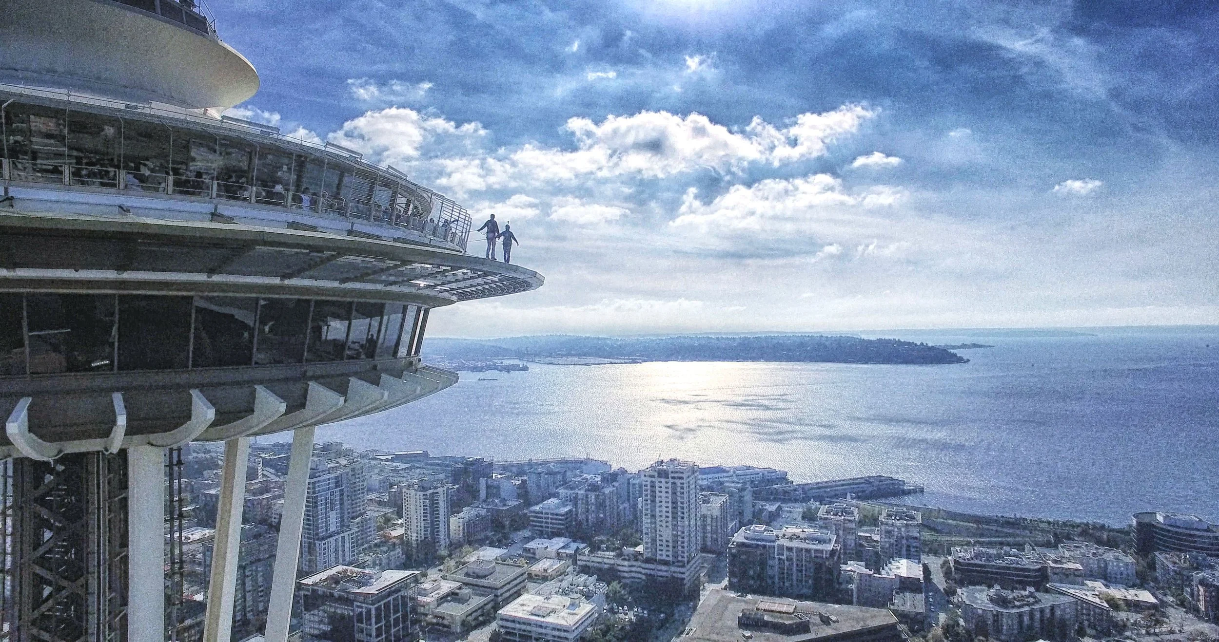
Seattle Space Needle: Gavin created interactive panoramic experiences for the Space Needle's observation deck, allowing visitors to explore hyper-detailed views of the Pacific Northwest in ways impossible through glass alone.
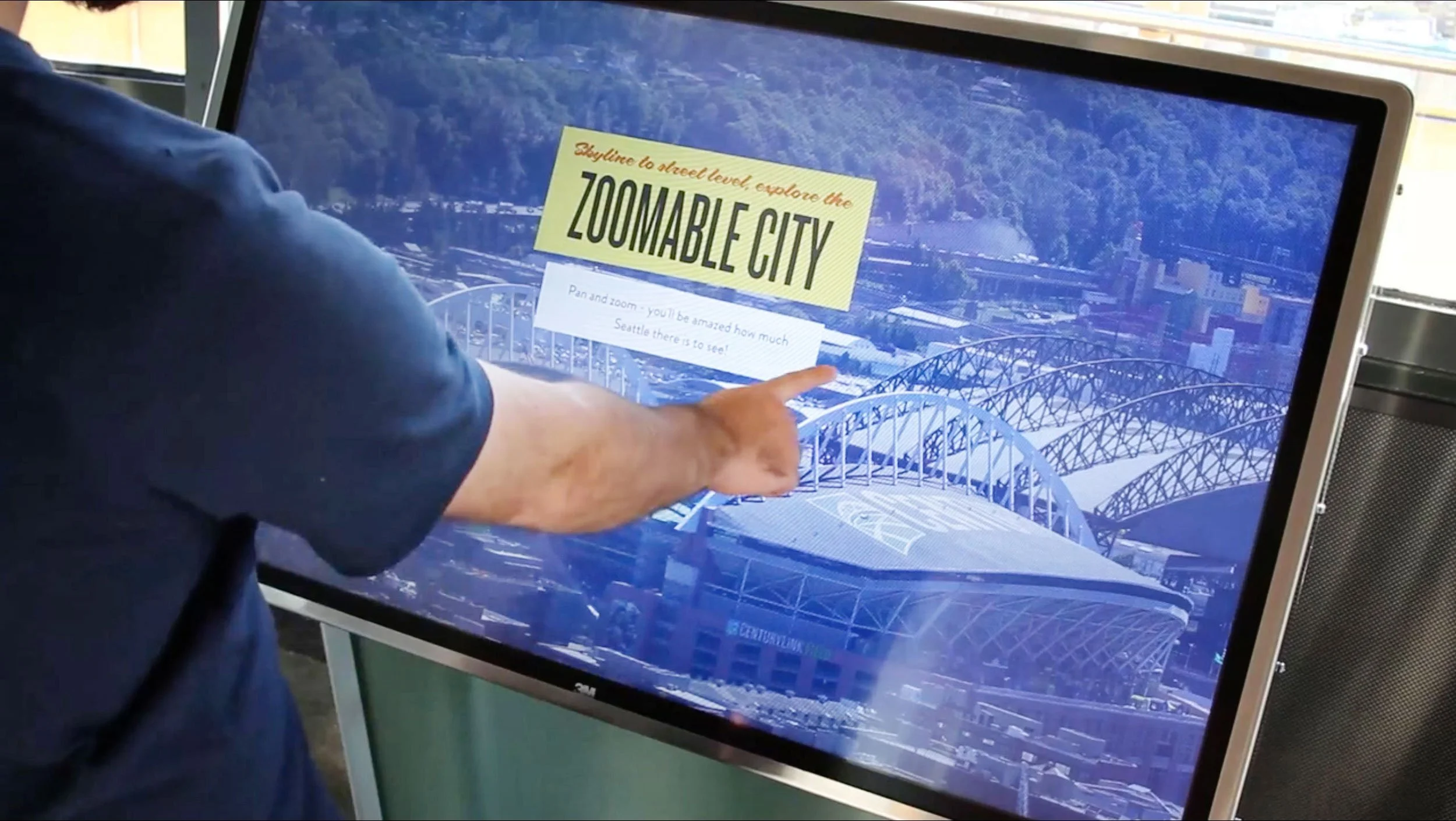
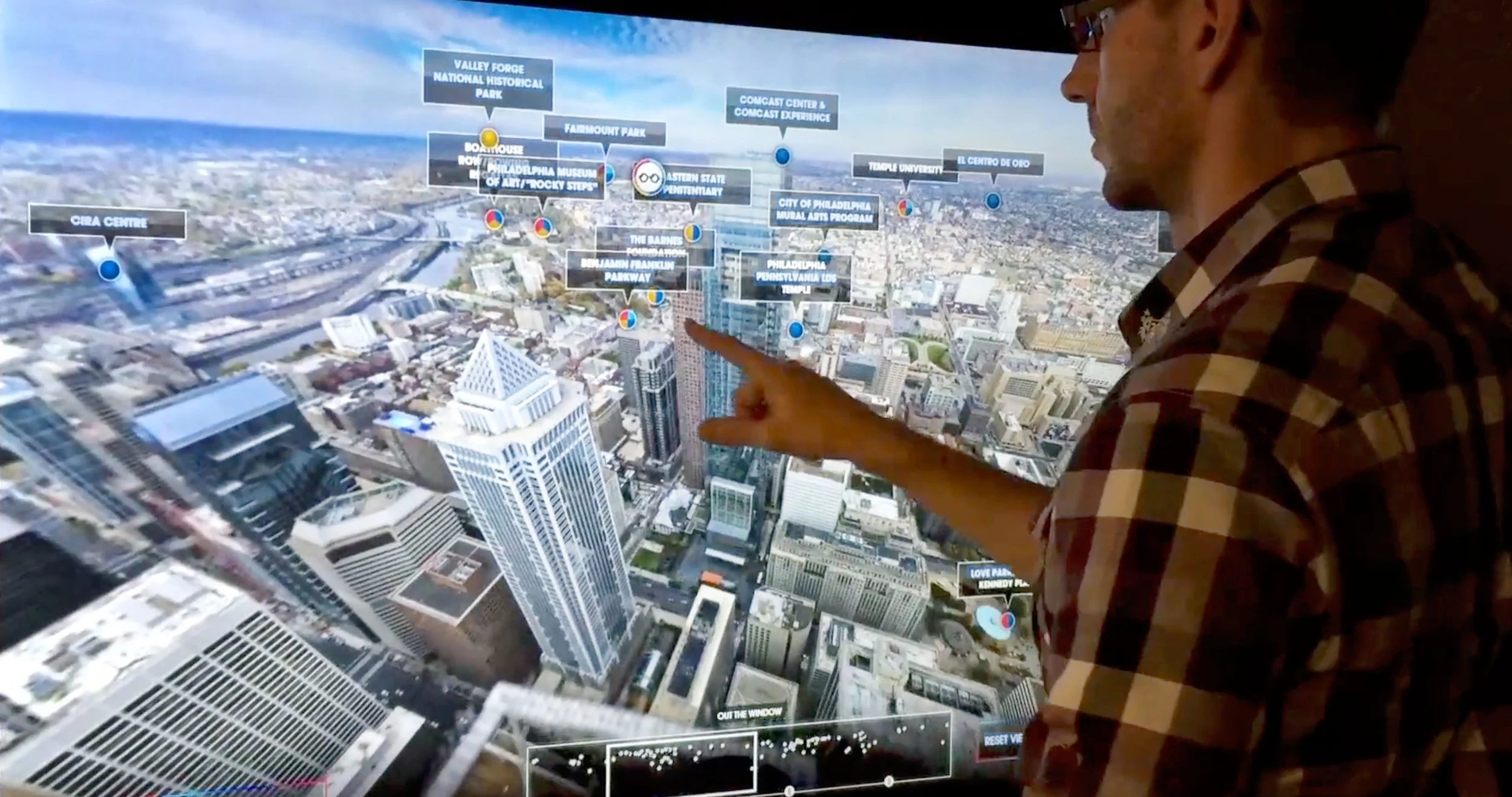
Philadelphia One Liberty Place: Similar installations enable guests to discover Philadelphia's cityscape through immersive, navigable 360-degree explorable panoramas of Philadelphia. Driven by six touchscreens throughout the observation deck, this experience features gigapixel-class images of the city, shot both in daytime and at night, with nearly 100 interactive points of interest with stories and even more photos.
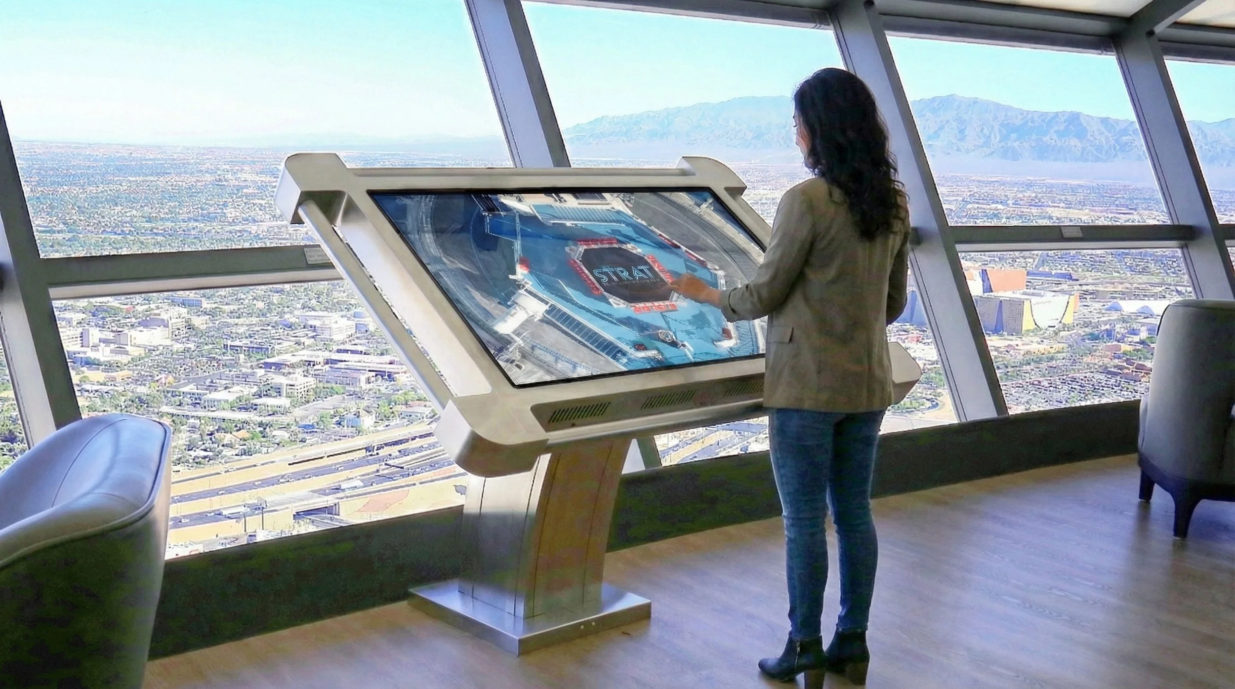
Las Vegas Stratosphere & Dallas Reunion Tower: Panogs mounted gigapixel cameras atop these landmarks, producing cinematic 360° vistas that capture entire metropolitan areas in unprecedented detail.
These installations fuse storytelling, interactivity, and immense scale, engaging the public with their surroundings in novel ways. Each project requires solving unique technical challenges, including different lighting conditions, varying architectural constraints, and distinct narrative opportunities, while maintaining the visual fidelity that defines Panogs' work.
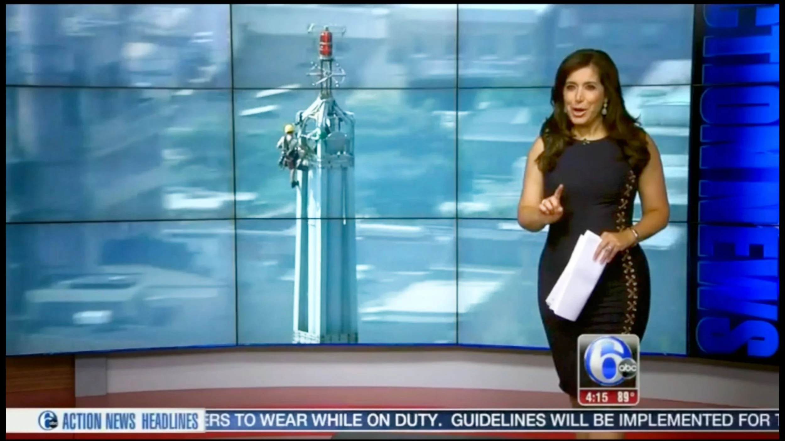
Sutro Tower 50th Anniversary Interactive Tour (2024–2025)
Featured by ABC7/KGO, SFist, and Radio World | explore.sutrotower.com/
For San Francisco's iconic broadcast tower's golden anniversary, Gavin led the immersive imaging team in creating what became a record-setting digital preservation project. Working at extreme heights on the 977-foot structure, the team captured a 1,300-gigapixel panorama, one of the highest-resolution architectural photographs ever produced.
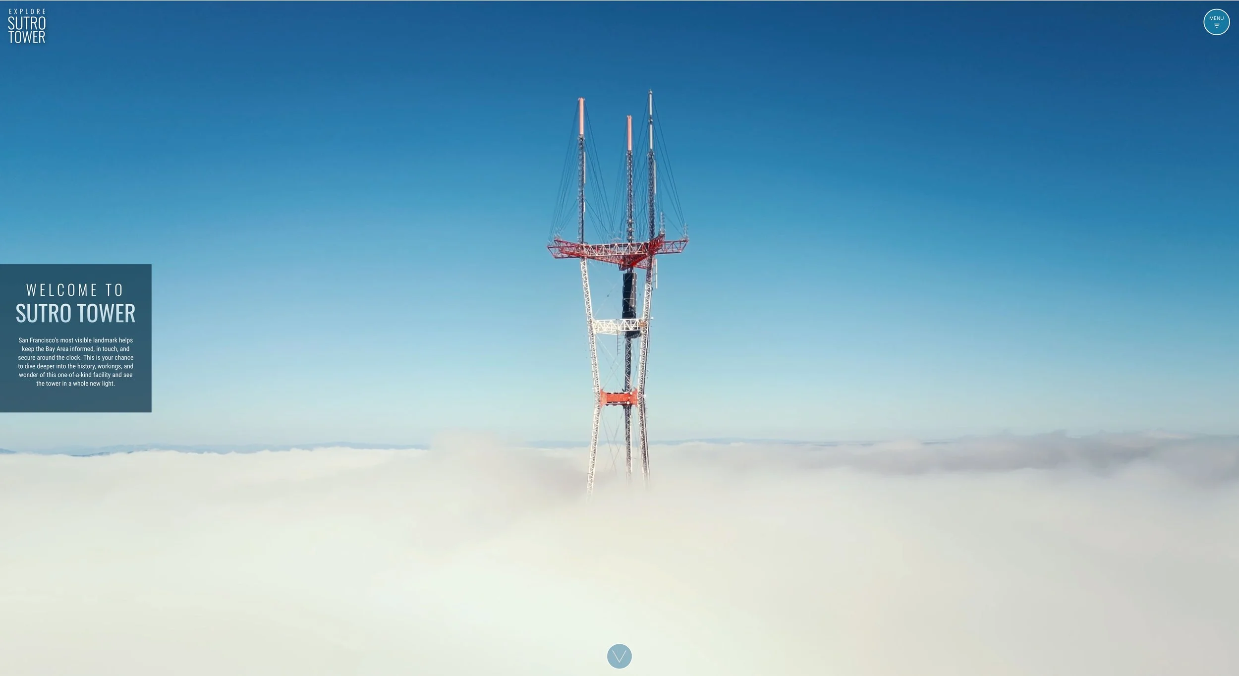
The project combined multiple imaging technologies: drone-based 360° photography mapped the tower's exterior, while LIDAR scanning and photogrammetric 3D reconstruction
The Earth Above: A Deep Time View of Australia's Epic History (2023–2024)
Best Narrative Film – Dome Fest West (2024) | Best Environmental Film – Sci-On! Film Festival (2024) | Silver Award – Portland Festival of Cinema, Animation & Technology (2024)
This 30-minute full-dome planetarium film explores Australia's geological and ecological evolution through a "deep time" lens, compressing 4.5 billion years of continental drift, extinction events, and biological transformation into an immersive cinematic experience. Produced in collaboration with Deakin University, the film required capturing Australia's vast landscapes in ways that conveyed both scientific precision and emotional resonance.
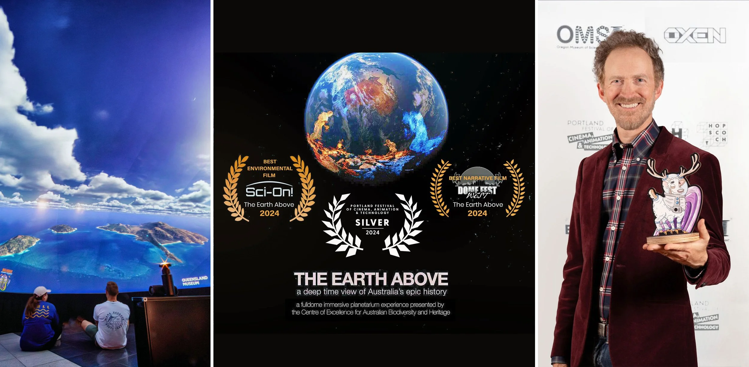
Gavin served as Immersive Media Designer, leading the design and deployment of custom drone and panoramic capture systems to photograph remote locations across the continent. His sweeping 360° shots of Australian landscapes projected on domed theater screens create a truly immersive experience, with audiences feeling suspended above ancient seabeds and primordial forests.
The technical challenge extended beyond capture: planetarium projection demands spherical imagery that wraps seamlessly around audiences, requiring specialized post-production workflows that preserve scientific accuracy while creating fluid, multisensory storytelling. The film's recognition at multiple international dome film festivals validated Gavin's approach to educational immersive media, treating dome projection not as a novelty format but as a uniquely powerful medium for communicating scale, time, and humanity's place within planetary systems.
VRDrones: Aerial Immersive Cinematography (2014–2025)
Vrdrone.io
Recognizing the need for tools that didn't exist commercially, Gavin co-developed custom VR drone technology for aerial 360° video capture through VRDrones. The proprietary dual-camera systems enable seamless stereoscopic capture, solving a fundamental challenge: how to film immersive aerial footage that maintains depth perception and spatial presence while operating from an unstable, remotely controlled platform.
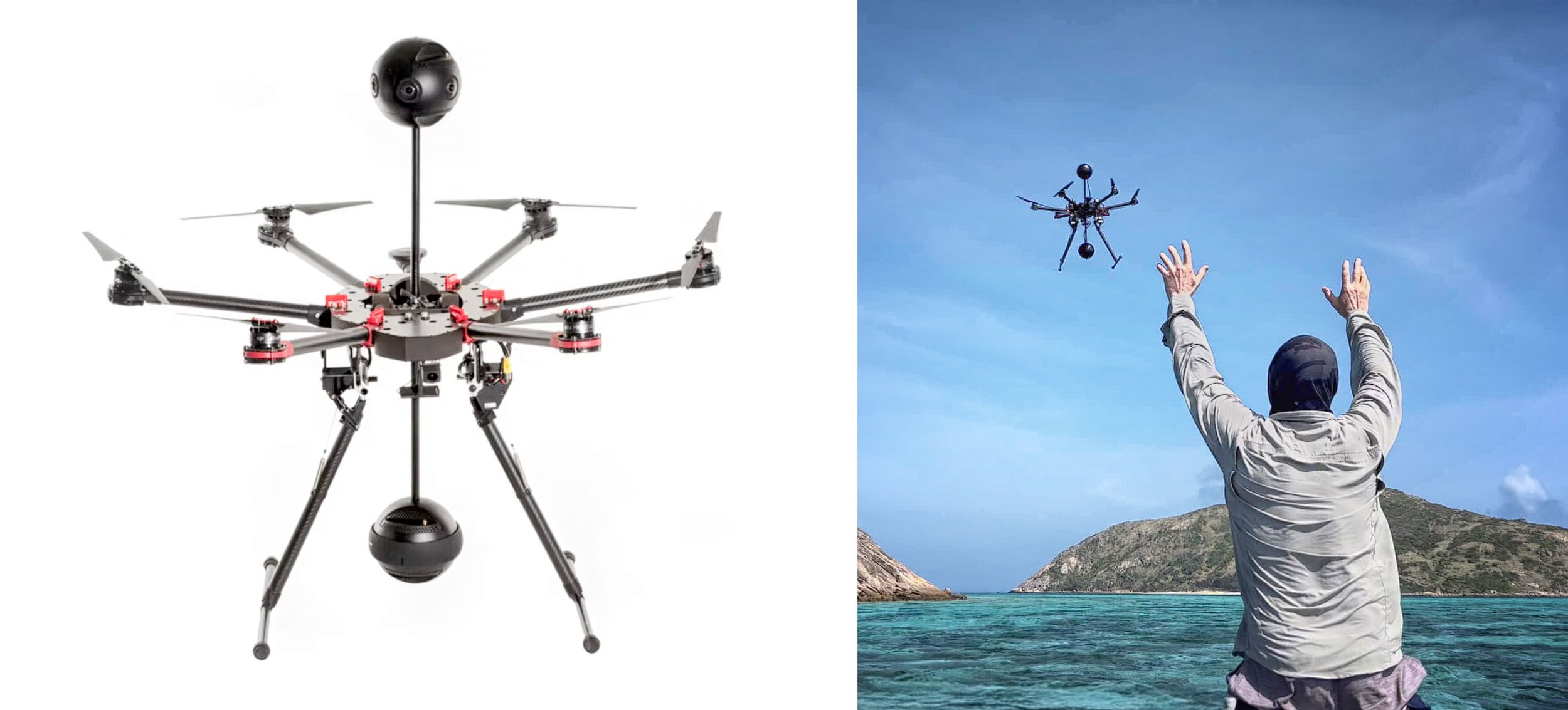
The innovation removed stitching seams and motion issues that plagued aerial VR footage, engineering drones capable of filming fully spherical, stable video in a single flight. This opened possibilities not only for immersive filmmaking but also for mapping, emergency response, and architectural documentation.
The Magic of Flight: A WebXR Experience (2020–2021)
Experience of the Year – The Polys WebXR Awards (2022) | Best Video Experience – The Polys WebXR Awards (2022) | Best Educational Experience – The Polys WebXR Awards (2022) - https://liquidcinemavr.com/fly/
In partnership with Thomas Wallner of Liquid Cinema, Gavin produced this immersive WebXR experience exploring the wonder of flight. The project represented a new distribution paradigm for VR content: rather than requiring expensive headsets, the experience runs directly in web browsers, dramatically expanding potential audiences.
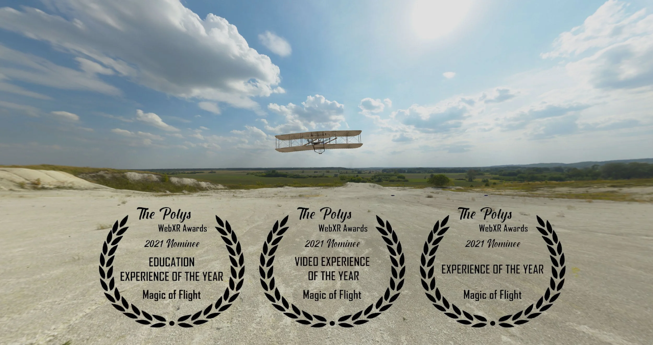
Gavin produced 180° stereoscopic footage using Z CAM K1 Pro Cinematic VR180 cameras, managing the full VR pipeline from multi-rig capture through spatial audio integration to interactive browser delivery. The project's sweep of Polys Awards (Video, Educational, and Experience of the Year) validated WebXR's potential as a democratizing force for immersive media.
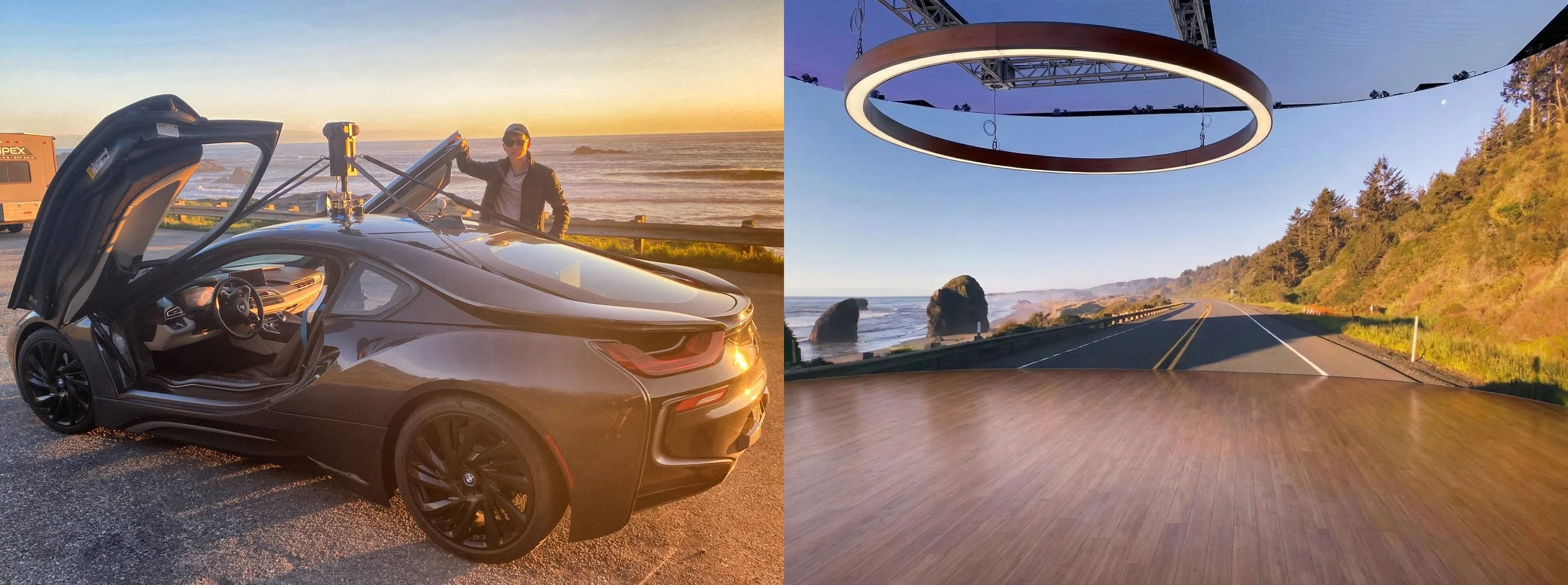
Luxicraft: LED Stage Virtual Production Content (2022–2023)
As Director of Immersive Videography at Luxicraft, Gavin launched the company's LED-stage-ready 360° content library for virtual production, the technology revolutionizing film and television production. Using META 3 Immersive cameras, he directed capture of ultra-high-resolution 12.5K spherical environments and developed workflows for cinematic ProRes backplates for LED Virtual production clients.
Hanson Robotics: Sophia the Robot (2018–2019)
At Hong Kong-based Hanson Robotics, Gavin led the international video production team showcasing Sophia, the world's most famous humanoid robot. The role required producing content that communicated complex AI and robotics concepts to general audiences while managing the unique challenges of filming an artificial intelligence celebrity.
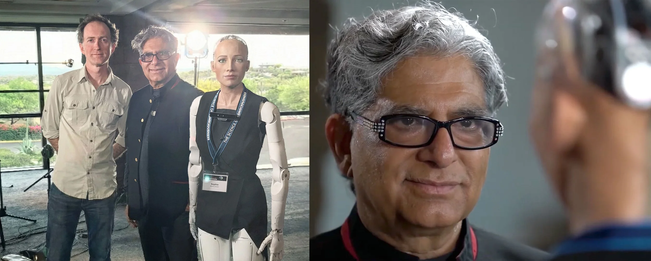
Gavin produced and directed Sophia's global interview series, public appearances, and branded content, including high-profile engagements with Deepak Chopra and United Nations events. Managing multi-country production logistics, he developed creative strategies that humanized the technology while maintaining scientific credibility.
Intel Museum Virtual Tour (2022)
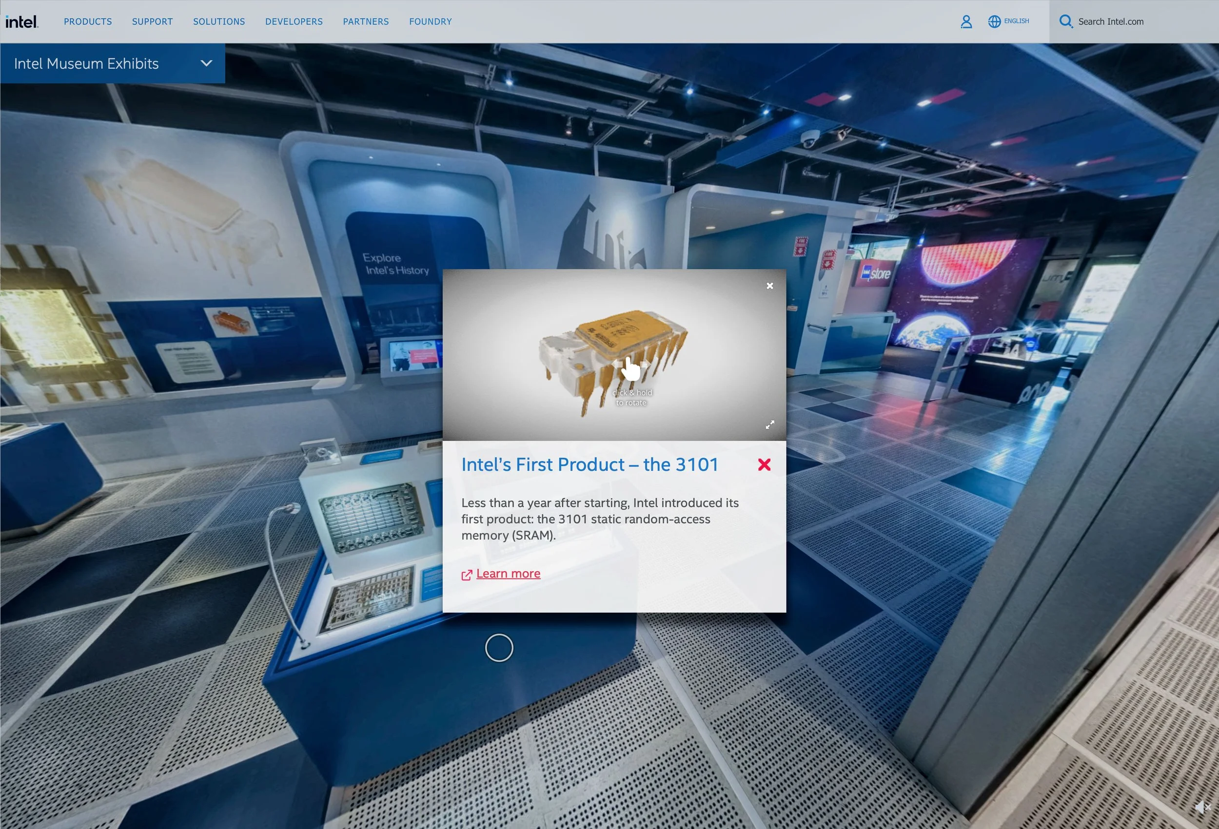
Gavin led the photographic capture for Intel's Virtual Museum, a comprehensive digital twin of the company's Santa Clara headquarters museum launched in May 2022. Working in partnership with creative agency Stimulant, he captured over 50 high-resolution gigapixel panoramas using Roundshot VR Drive robotic camera heads, creating a seamless explorable replica of the 3,500-square-foot space that showcases Intel's 50-year hardware legacy. Macroscopic Photogrammetry of the tiny computer chips
Q5id: Identity Protection Social Media Campaigns (2022–2023)
Gavin produced national broadcast and social media campaigns for Q5id's identity protection and safety products, including directing the Guardian App launch campaign featuring Elizabeth Smart. He developed motion-graphic explainers including "The Cost of an Account Takeover" and "Know Your Employees," overseeing creative strategy, production teams, and post workflows for cross-platform distribution.
The Panographers: VR Photography Podcast (2010–2015)
https://www.youtube.com/@panographerspodcast
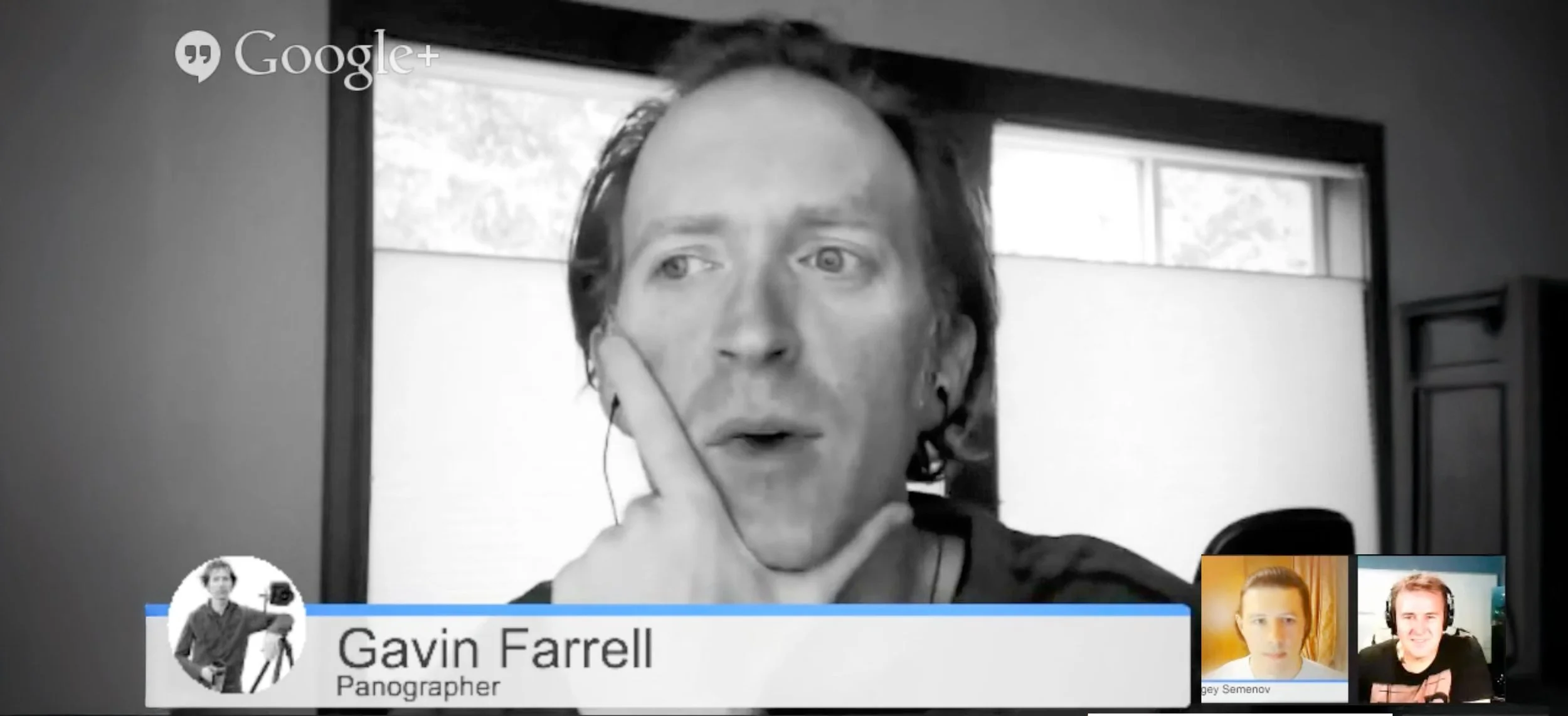
The Panographers was a pioneering 360° video podcast launched by Gavin in the mid-2010s, broadcast live twice monthly. Each episode featured interviews with experts across panoramic photography niches, covering topics from underwater 360° imaging and gigapixel landscapes to astrophotography techniques and aerial panoramas, with notable guests including AirPano co-founder Sergey Semenov. The series, hosted on YouTube and the Panogs website, served as both a bleeding-edge experiment in immersive podcasting and a valuable oral history of the panoramic photography community, exemplifying Gavin's dual role as educator and innovator in the field.
Technical Capabilities
Immersive Capture Systems Custom 360° camera rig design and deployment, stereoscopic VR capture and post-production, gigapixel panoramic photography, drone-based aerial immersive cinematography, LIDAR scanning and photogrammetric 3D reconstruction, Gaussian Splatting 3D modeling
Production Expertise VR/AR experience design and direction, fulldome film production and projection workflows, virtual production for LED stages, interactive installation design, WebXR development and optimization
Creative Direction Motion graphics and animation, rich-media advertising and interactive campaigns, documentary and branded content production, cross-platform content strateg